
Space Apps Challenge

From to , participants from Halifax, Montreal, Ottawa, Toronto, Waterloo, Edmonton and Calgary will join programmers, designers, students, engineers and entrepreneurs from all over the world to create original computer applications at NASA's Space Apps Challenge . This international programming marathon takes place over 48 hours in various cities around the world. Participants will share their ideas and use open data to solve concrete issues experienced on Earth and in space.
The Canadian Space Agency (CSA) is participating for the third year in a row. Based on its experience, the CSA has come up with six challenges that will be presented at events in Canadian cities.
- Challenge 1: STRATOS
- Challenge 2: Go Canada – Geomagnetic Data Integration
- Challenge 3: NEOSSat – Canada's Space Surveillance Telescope
- Challenge 4: Radi-N2 Interactive Map: Graphical Representation of Radiation Across Canada
- Challenge 5: SCISAT – Canada's Atmospheric Chemistry Experiment
- Challenge 6: RADARSAT-1 Open Data
- RADARSAT-1 Kids' Challenge
Challenge 1: STRATOS
The CSA uses stratospheric balloons to test and validate new technologies designed for long-duration space missions and to conduct scientific experiments in a space-like environment. The CSA captures in-flight images and compiles telemetry data (altitude, speed, atmospheric pressure, temperature, etc.) related to balloon movement. Since this variety of data is of definite use to scientists involved in STRATOS experiments and to the general public, it is freely disseminated and accessible to all.
Give us a solution that will make it easier to consult this information and that will highlight this data on the environment of the stratosphere.
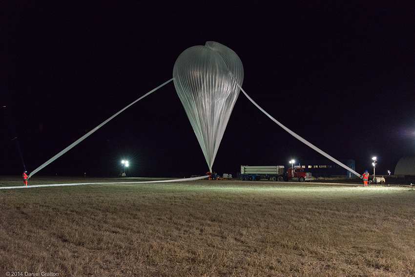
Stratos: the CSA stratospheric balloon program (Credit: CSA)
Your challenge
The objective of this challenge is to create a Web-based Dashboard tool that will allow scientists involved in research projects, as well as the general public, to consult, visualize and/or easily interpret images and telemetry captured from stratospheric balloons during the Austral and Strato-Science campaigns.
Challenge 2: Go Canada – Geomagnetic Data Integration
Help scientists improve Canadian geomagnetic datasets – essential for tracking Earth's magnetic field responsible for protecting people from solar flares – by
- developing an algorithm to identify non-geomagnetic measurements; and
- using the Canadian magnetometer network to determine geomagnetic activity across Canada.

Computer simulation of Earth's magnetic field in a period of normal polarity between reversals. (Credit: Wikipedia)
Your challenge
The first objective of this challenge is to identify erroneous data collected by magnetometers by developing a validation algorithm for a dataset. Magnetic measurements are sometimes influenced by non-geomagnetic phenomena (e.g. lighting, high-voltage lines, power outages). It is therefore important to identify these erroneous measurements so as not to associate them with solar events.
The second objective is to produce a map of Canadian geomagnetic activity and use it to estimate its condition at any location in Canada. Producing a good model to simulate large-scale geomagnetic activity is particularly important because of the irregular layout of the measurement sites, the large land mass of Canada and the hostile climate of Canada's Far North. Good interpolation would allow the estimation of geomagnetic activity at thousands of kilometres from a measurement site without the need for construction and support of other sites of observatories.
Challenge 3: NEOSSat – Canada's Space Surveillance Telescope
The CSA needs a solution to effectively search the NEOSSat database and identify images based on various criteria. The CSA also needs a solution to locate asteroids or other types of objects on images captured by NEOSSat.

M31 Andromeda Galaxy observed by NEOSSat (Credit: Captain Kevin Bernard, Royal Canadian Air Force)
Your challenge
The goal of this challenge is to explore near-Sun images and find a way to identify asteroids. If you can also find solutions to optimize their use, it's even better! If you have a creative soul, even create your own animation from images where you have identified asteroids!
Challenge 4: Radi-N2 Interactive Map: Graphical Representation of Radiation Across Canada
Make the most of David Saint-Jacques', Chris Hadfield's and Robert Thirsk's missions to help Canadians visualize or interpret radiation data collected on the ISS and on Earth.
David Saint-Jacques explains radiation in a CSA video. (Credit: CSA)
Your challenge
Help Canadians visualize and interpret radiation data collected on the ISS during the missions of Canadian astronauts David Saint-Jacques, Chris Hadfield and Robert Thirsk, and collected on land at various locations across Canada.
Challenge 5: SCISAT – Canada's Atmospheric Chemistry Experiment
In order to compare atmospheric gas concentrations over time, the CSA must be able to identify atmospheric events such as ozone holes, forest fires and volcanic eruptions. The concentrations during those events should be compared with concentrations from periods of the year when gas concentrations are nominal, in order to establish the differences between them.
These atmospheric events occur over a specific geographic area of Earth or ocean in a similar period of time year after year. A good comparison tool would allow identifying the difference (i.e. the increase or decrease) in gas concentrations based on time and geographic location.

Artist's view of the SCISAT satellite (Credit: Bristol Aerospace)
Your challenge
Explore significant concentrations of atmospheric gases measured by SCISAT to help identify timely events over specific geographic locations.
Challenge 6: RADARSAT-1 Open Data
Calling all programmers and computer geniuses! The Government of Canada is committed to making its data available. Its open government initiative includes scientific data. Therefore, the CSA is trying to make as much RADARSAT-1 satellite data available to the public as possible.
Currently, just 2% of RADARSAT-1 data is open, because the rest of it is in raw format (i.e. not processed). That means that in order to provide access to that data, the CSA first has to process it. To reduce the processing costs, which can be very high, the CSA would like to identify and prioritize datasets that could be useful for research purposes. To do this, a script is needed to automate searches in the Earth Observation Data Management System (EODMS).

RADARSAT-1 satellite (Credit: CSA)
Your challenge
The objective of this challenge is to assist the CSA and NRCan (Natural Resources Canada) in making more RADARSAT-1 data available to the general public.
Create a script to automate searches in the EODMS.
More information on accessing the EODMS Open Search API (BETA) can be found on the GCWiki page.
Prize and awardsFootnote 1
Winners of each challenge in participating cities will receive a prize from local judges. Following the closing of the Space Apps Challenge, one of these teams that proposed solutions to CSA challenges will later be identified as the big winner. The winning team will have the opportunity to be mentored for two consecutive days at the CSA's John H. Chapman Space Centre in Longueuil, Quebec. They will also be invited to present their solution(s) to members of the CSA's Executive Committee.
In addition, this year the CSA is holding an exhibition challenge for young explorers!
RADARSAT-1 Kids' Challenge
Your challenge
You want to build a satellite or analyze a true radar satellite image? Jump on this challenge and show us what you're made of!