
Kootenay National Park
In southeastern British Columbia, straddling the Alberta border, lies Kootenay National Park. Embodying the best of the Canadian Rocky Mountains, awe-inspiring valleys, soaring mountain peaks, pristine lakes, and relaxing hot springs await the many thousands who visit the park every year. In a world of constant and often rapid change, our national parks can seem frozen in time, providing a link between ourselves and bygone times and peoples. Yet this is not wholly true; our parks are constantly changing, being shaped and reshaped by both natural and human forces. Earth observation satellites and their archive of historical images offer us the ability to peer into the past and visualize these forces occurring across time and space.
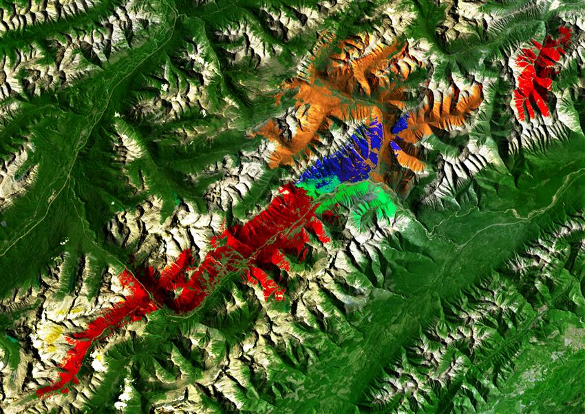
Of these forces of change, perhaps the most dramatic is fire. Simultaneously destructive and creative, fire is an essential and immutable part of Rocky Mountain forests.
Credit: Sparkgeo. Landsat 8 image courtesy of the USGS
About the visual art
- Location: Kootenay National Park of Canada, British Columbia
- Company: Sparkgeo
The image above shows Kootenay National Park as captured by Landsat 8 in . Painted across the landscape in a kaleidoscope of colours are the scars from fires that raged through the park over the last two decades. Each colour represents a fire from a different year: (blue); (red); (orange); and (green).
Each fire scar was mapped using data from the Landsat program, from images taken shortly after the fire. With an archive dating back to , Landsat represents the longest continuous record of satellite-based Earth observation data globally and is a priceless resource for understanding landscape change.
Eventually, no physical trace will be left of these fires that once ravaged Kootenay National Park. Only the satellite record will remain to tell the tale.