
Jasper National Park
Jasper National Park, one of five national parks in Alberta, is a popular tourist destination that offers a 10,000-year glimpse into the past when glaciers covered most of Canada and extended south into the United States. Hiking, camping, and glacier tours are among the opportunities that can be enjoyed in this unique environment. As global temperatures rise, these natural wonders are receding at a significant pace.
Credit: Vertex Resource Group. Contains modified Copernicus Sentinel-2 data processed by ESA
About the visual art
- Location: Jasper National Park of Canada, Alberta
- Company: Vertex Resource Group
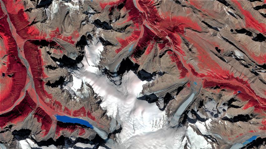
This stunning image of the Columbia Icefield and the Athabasca Valley uses a combination of near-infrared, red, and green wavelengths to highlight vegetation and icefield features. The Athabasca Glacier is visible extending northeast from the central icefield towards the Sunwapta River in the Athabasca Valley. On the western side of the icefield, you can see the Columbia Glacier and its recessional moraines heading towards the meltwater lake that feeds the Athabasca River. The lake is much larger today than 30 years ago when the glacier extended farther west. Darker reds depict predominantly old-growth coniferous forests along the valley bottom and lower slopes while the lighter, brighter reds represent shrubs, grasses, and young trees.
Vertex has been leveraging open-source imagery such as this one to map wetland disturbances and vegetation conditions. This image showcases one method of incorporating beyond-visible wavelengths of light more suited to differentiating vegetation from other land cover types.
Michael Henley has been integrating remotely sensed imagery to characterize land cover and land cover change for over 20 years, having started with the Canadian Forest Service Earth Observation for Sustainable Development program to create a land cover map of Canada. His extensive experience allows him to evaluate project goals and identify relevant resources, future challenges, and implement solutions for all types of geospatial analysis in the natural resources sector including pipelines, oil and gas operations, mining, and forestry. Michael is currently working on two CSA-funded smartEarth projects leveraging Vertex's artificial intelligence capabilities.