
SWOT: A mission that will change how scientists study surface water on Earth
On , NASA launched the Surface Water and Ocean Topography (SWOT) mission, a collaboration with France's space agency Centre national d'études spatiales (CNES) that also includes the Canadian Space Agency (CSA) and the United Kingdom Space Agency.
SWOT will survey 90 percent of Earth's surface water. The mission has major implications for scientists working to better understand the dynamics of the world's oceans, rivers, lakes and reservoirs. Data from SWOT will help researchers address important global issues like climate change and Canada's management of water.
Here are six things to know about the fascinating science behind SWOT.
SWOT will vastly expand what we know about the ocean's surface
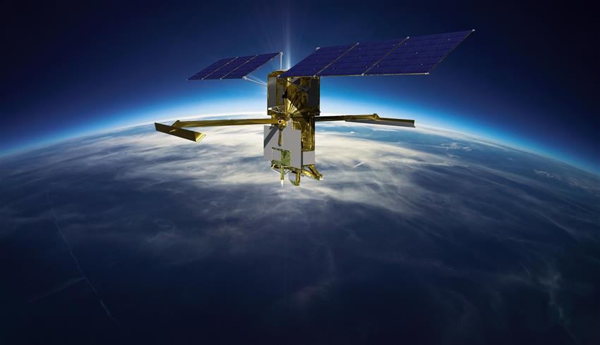
Artist's rendering of the SWOT satellite collecting precise water measurements. (Credit: CSA)
The ocean's surface is a rich source of information that scientists can use to better understand weather, climate, ecosystems and life all over the world. For many years, satellites and ocean buoys have given scientists at Fisheries and Oceans Canada data about marine winds, ocean waves, sea ice, and contaminants such as oil pollution and dirty bilge water.
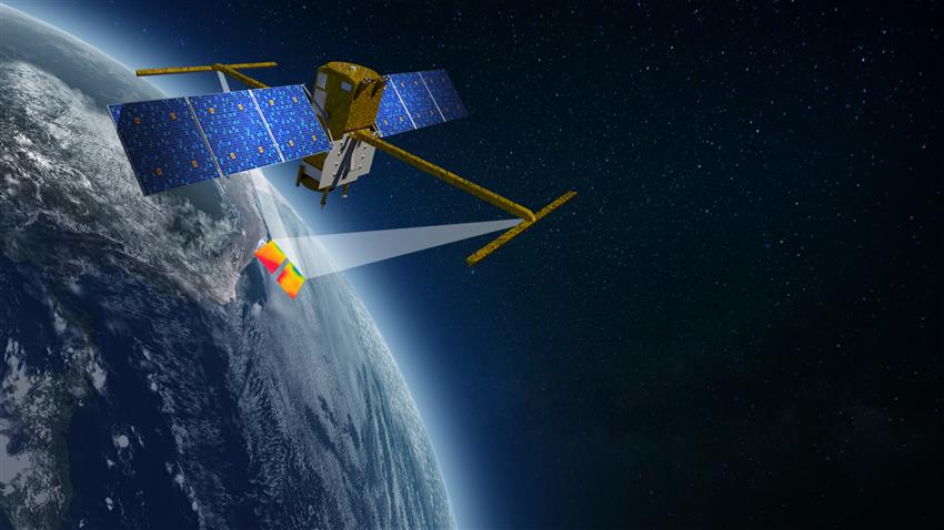
With the SWOT launch, wide avenues of inquiry are opening as huge new data sets become available to complement data from older satellites. SWOT will take measurements over 120-km-wide swaths of area. When stitched together, these swaths will provide researchers with exponentially more information than before about the ocean's surface, including new information about major features such as the Labrador Current and the Gulf Stream.
These rich data sets will help scientists improve ocean current forecasting and marine weather prediction in sensitive coastal areas, as the new data is assimilated into existing forecast models. More than that, SWOT mission data will ultimately help scientists better understand longer-term weather patterns and predict with more confidence the climate change scenarios that are an inevitable part of our future.
SWOT data will help scientists protect whales and other species
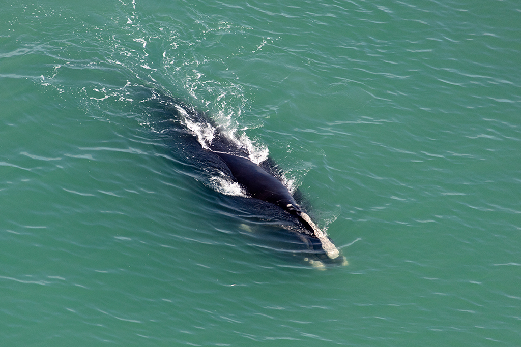
North Atlantic right whale in Canadian waters.
SWOT data will also help build more sophisticated models for ecosystems, and learn more about how physical oceanography influences fisheries and various biological species. As one example, SWOT will contribute to a project to protect North Atlantic right whales in Canadian waters, says William Perrie, a research scientist with Fisheries and Oceans Canada. By tracking the Gaspé Current in the Gulf of St. Lawrence, researchers can determine where zooplankton are possibly found and, therefore, where right whales might gather to feed. This crucial information could help protect whales against vessel collisions and fishing gear entanglements in our waters.
SWOT scientists will transform modelling for water resource management

Infographic presenting elements to be studied by Canadian scientists with SWOT mission data. (Credit: CSA)
At Environment and Climate Change Canada (ECCC), SWOT data will enable scientists to carry out a Canada-wide water balance that will give them key information about lake levels across the country, says Daniel Peters, a research scientist with ECCC. And at Université de Sherbrooke, which works closely with ECCC, researchers such as Mélanie Trudel are developing new approaches to integrate future SWOT data into existing water resource management models.
Lake level, river slope and river discharge data, when added to hydrological models, will yield a much more accurate picture, says Trudel. More accurate water discharge forecasts are useful for organizations such as Hydro-Québec or provincial governments, which need to know where water is (and will be) distributed among the lakes and rivers of a watershed.
Researchers will also integrate SWOT data that is spatially distributed into water-balance models, which examine a reservoir or lake and calculate the rate at which water flows out. These models are used by dam managers to optimize such things as hydropower production, and to reduce the effects of flooding.
Developing sound modelling and accurate water-balance forecasts will be increasingly important in the context of climate change. SWOT will help scientists predict major changes in water flows and, as a result, protect communities and infrastructure. With climate change, it will be more difficult for water resource managers to optimize hydropower production as heavy rains, storms, winter flooding and drought become harder to predict.
SWOT will help unravel the mysteries of northern lakes

Canada's lakes account for 62% of all lakes in the world (in blue). (Credit: HydroLAKES)
Hydrologists who are working in Canada's Arctic, such as Wilfrid Laurier University's Philip Marsh, will use SWOT data to study shallow thermokarst lakes from north of Inuvik to the Beaufort Sea. This area has some of the highest concentrations of lakes not just in Canada, but anywhere in the world. The tens of thousands of lakes in this region are important as habitats to waterfowl, fish and other species, and also important for hunting, trapping, fishing and recreation for northern communities, says Marsh.
SWOT will for the first time provide accurate data on the water surface elevation of lakes across the Arctic. This will significantly improve understanding of all aspects of Arctic water. As one example, SWOT will capture a phenomenon known as "catastrophic lake drainage" where an entire lake, often up to 2 km across, can completely drain in a single day. Lake drainage is a natural event. However, it is believed that warm temperatures resulting from climate change create conditions that enhance melting of permafrost ice that surrounds the banks of these lakes, and therefore increases the number of lakes draining each year. As entire lakes drain, the water flows downstream through the existing stream network, but in some cases creates new stream channels. Lake drainage results in major floods, impacting habitats, and creating hazards to stream users and cabins. Eventually it converts lake habitat to tundra habitat.
Until now, hydrologists have witnessed very few catastrophic drainage events. SWOT data will enable them to witness the phenomenon in near real time for many lakes each year. This will help scientists determine if the number of draining events is increasing as the climate warms and permafrost ice thaws, and what effects we will likely see across the Arctic under various future climate change scenarios.
Why should we care about these remote lakes draining? The total area of thermokarst lakes across the Arctic is roughly the size of the Greenland ice sheet and is almost as large as the Amazon rainforest. As temperatures continue to rise in the Arctic, it is conceivable that all such lakes could completely drain in the future, with dramatic impacts on people, ecosystems and climate of the Arctic.
SWOT will undergo a period of validation to ensure accurate operations

During the calibration and validation phase, Canadian scientists will validate the data coming from SWOT to ensure its measurements are accurate. (Credit: Mélanie Trudel)
During the three months after SWOT's launch, engineers will adjust its orbit and ensure its systems are working properly. Next, Canadian scientists will participate in a three-month calibration and validation phase where instruments on Earth will validate the data coming from SWOT to ensure its measurements are accurate.
During validation, SWOT will follow a one-day repeat orbit instead of the 21-day orbit the satellite will follow during regular operations. This orbit will yield rich data for the area it covers, which in Canada includes the Pacific coast, the Peace-Athabasca Delta, multiple Prairie lakes, the St. Lawrence River, the Atlantic coast and many more, says CSA Mission Scientist Jean Bergeron, who is also a hydrologist.
SWOT relies on a vital Canadian innovation
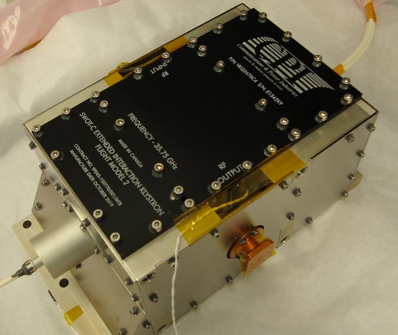
The CSA provided a set of extended interaction klystrons (EIKs) – a key component of NASA's radar instrument. (Credit: Communications & Power Industries Canada Inc.)
The CSA has provided a key component of SWOT's Ka-band radar interferometer (KaRIn), the instrument that NASA will use to gather data from the surfaces of lakes, oceans and other bodies of water and calculate their elevation. KaRIn emits light in the microwave region of the electromagnetic spectrum and then measures the light reflected by Earth's surface that returns to SWOT. But this instrument works only if KaRIn's radar signals are amplified as high-power pulses. From its Ontario facility, Communications & Power Industries Canada Inc. has provided this key technology, called extended interaction klystron technology, to enable this process.