A SOAR success: Learning about glaciers from space!
Glaciers and climate change
Glacier changes can have an impact on ecosystems and communities in northern Canada. Ice movement and melting, for example, can lead to higher sea levels, fewer freshwater resources, and important ecosystem changes.
Scientists study how glaciers change over time to better understand the interplay between climate and glacier dynamics. And satellites, like RADARSAT-2, are helping them!
Did you know?
Glaciers are constantly moving. It may be hard to imagine, but ice moves—as solid water. The way it moves is determined by many factors, including gravity, climate and specific characteristics of a glacier such as temperature. The thicker and steeper the ice, the more it moves, with the surface and centre of the glacier moving more rapidly than the sides and bottom, which are held back by friction.
Glaciers are also melting. Ice movement and melting may be related, but they are not the same thing. In fact, the more the ice melts (or thins), the less it moves.
Glaciers are essential indicators of climate change. Glaciers react to current variations in climate, and ice cores extracted from glaciers help scientists study the history of climate on Earth.
University of Ottawa project
With support from the Canadian Space Agency (ASC), the University of Ottawa successfully used RADARSAT-2 imagery to study ice movement and ice changes in the St. Elias Mountains, where we find some of the largest non-polar glaciers in the world. This mountain range straddles Alaska, Yukon and British Columbia and is home to Mount Logan, the highest mountain in Canada.
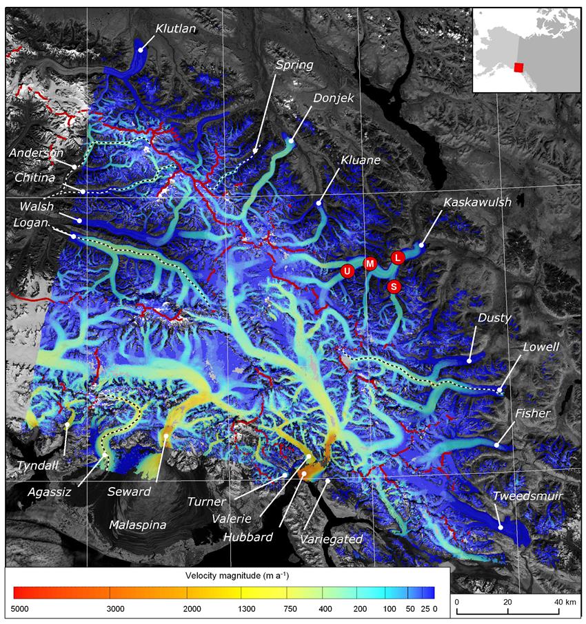
This study provided the first complete view of ice velocity across the St. Elias Mountains and allowed researchers to see significant variations in the speed of ice movement throughout the region.
The project also confirmed that observing glacier dynamics from space is effective and practical. While it takes about an hour to fly across the St. Elias Mountains and 20 minutes to fly over the Kaskawulsh Glacier, RADARSAT-2 images are captured in seconds as the satellite flies over the region and can show movement as small as 2 cm per day (50 cm over 24 days).
Project: Ice dynamics of the Kaskawulsh Glacier, Yukon

Surface ice velocity across the St. Elias Mountains (Credit: Waechter et al. (2015), Journal of Glaciology)
Project: Ice dynamics of the Kaskawulsh Glacier, Yukon
Description: Using high-resolution RADARSAT-2 imagery from and , researchers studied glacier movement in the St. Elias Mountains. The precise information on the speed and direction of ice movement showed significant variations across the mountain range. Glaciers on the western side of the mountains moved more quickly (up to 5 km per year) because of the very high snow accumulation rates in this region. Glaciers on the eastern side of the mountains moved much more slowly (about 200 m per year) because of the lower snow accumulation there. In addition, comparing RADARSAT-2 imagery with previous satellite measurements showed that movement in the lower part of the Kaskawulsh Glacier has slowed since the late s, likely due to dramatic ice thinning in this area.
These measurements provide the first complete view of ice velocity across the St. Elias Mountains. The results build on past measurements to provide a more comprehensive baseline against which future ice motion measurements can be compared.
Lead: Dr. Luke Copland, Associate Professor, Department of Geography, University of Ottawa (Ontario)
Related Publication(s): Waechter, A., Copland, L. and Herdes, E. 2015. Modern glacier velocities across the Icefield Ranges, St. Elias Mountains, and variability at selected glaciers from to . Journal of Glaciology, 61(228), 624-634. doi: 10.3189/2015JoG14J147. (PDF version of the Modern glacier velocities across the Icefield Ranges, St. Elias Mountains, and variability at selected glaciers from to publication)
The CSA and Earth observation applications & utilizations
The CSA supports research and development projects to maximize the use of satellite imagery and develop products and services that help scientists and researchers better understand our planet and improve management of natural resources. This project, "Ice dynamics of the Kaskawulsh Glacier, Yukon," was supported through the Science and Operational Applications Research (SOAR) Program.
