
Data Compendium: 20 years of radar images

Data Compendium - A summary of 20 years of radar imaging overt the polar regions
Credits: NASA/JPL, UCI, Canadian Space Agency (CSA), European Space Agency (ESA), Japan Aerospace Exploration Agency (JAXA)
Monitoring the Earth's poles
Although the icy landscapes of the Earth's polar regions may seem distant to most of us, the scientific community has grown increasingly concerned about the significant warming that is occurring at the poles and has recognized the urgent need to gain a better understanding of current and potential impacts. In fact, it has been observed that the Earth's poles are experiencing a warming effect at twice the rate of the rest of the world. Such a global issue can only be addressed through scientific leadership, research and collaboration.
In , the World Meteorological Organization established the Polar Space Task Group and its subsidiary Synthetic Aperture Radar Coordination Working Group, with the mandate to better coordinate the collection of satellite radar data over the polar regions. Through the coordinated efforts of representatives from space agencies, international organizations and the scientific community, several thousand images were acquired over a period of more than two decades. This coherent and extensive compilation is one of the richest and most diverse datasets ever generated and it contributes to our understanding of the impact of climate change on the polar regions.
The images are made available to the scientific community to encourage observation, analysis and, hopefully, novel answers to important science questions.
To raise awareness of this initiative, the Polar Space Task Group is releasing a compilation of 20 years of imaging activities that features unprecedented views and insights related to both poles. This Compendium of radar images focuses on four thematic areas: ice sheets, floating ice, permafrost, and snow.
To access the Data Compendium.

High resolution colour images of permafrost in northern Canada, captured by TerraSAR-X satellite (Germany) in . (Credit: DLR, Germany)
Canadian contribution
Canadian Earth observation satellites have played an important role in monitoring the polar regions over the last 20 years. Our key role is enabled by our RADARSAT satellites, which use advanced radar technology to acquire images at night, through cloud cover and in all weather conditions. This imaging capability is ideal for monitoring the vast regions of the Canadian Arctic during the long polar night and the cloudy summer season.
Through its RADARSAT program, Canada has conducted routine surveillance of both poles, which has included monitoring of sea ice and ice sheets.
The capability to chart sea ice allows information to be provided to operational ice mapping services on a daily basis in support of safe navigation. In addition, integrated seasonal sea ice data contribute to a better understanding of the impacts of climate change in the Arctic.
RADARSAT-1 and RADARSAT-2 have also imaged the world's ice sheets, providing a unique long-term dataset for close to 20 years. In fact, RADARSAT-1 (-) was the first satellite to produce a complete high-resolution map of the Antarctic, and RADARSAT-2 (launched in ) is still being used for ice sheet monitoring.
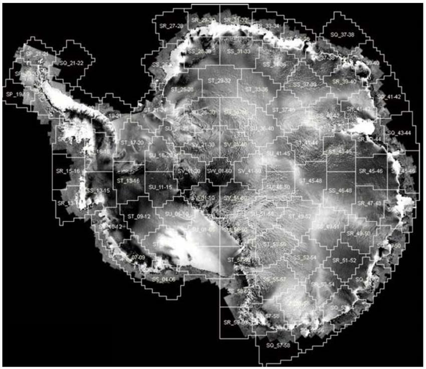
In , the first mosaic of the Antarctic continent was completed with radar images acquired by Canadian satellite RADARSAT-1. Data available through the Polar Data Catalogue. (Credits: CSA, Ohio State University, Alaska Satellite Facility)

First high resolution mosaic of the Antarctic continent produced by RADARSAT-2 in honour of International Polar Year (). Data available through the Polar Data Catalogue. (Credit: RADARSAT-2 Data and Products © MacDonald, Dettwiler and Associates Ltd. () All Rights Reserved. RADARSAT is an official mark of the Canadian Space Agency)
Those two examples constitute a unique Canadian legacy for climate change sciences, providing the scientific community with a rich source of geophysical information that documents environmental changes affecting the Earth's polar regions.
Through its contributions to mapping and protecting the polar regions since , Canada has played a key role in supporting the Polar Space Task Group's efforts to collect and compile archival radar imagery. The datasets collected by the Canadian RADARSAT missions over the polar regions are described in the newly released Compendium of radar images.
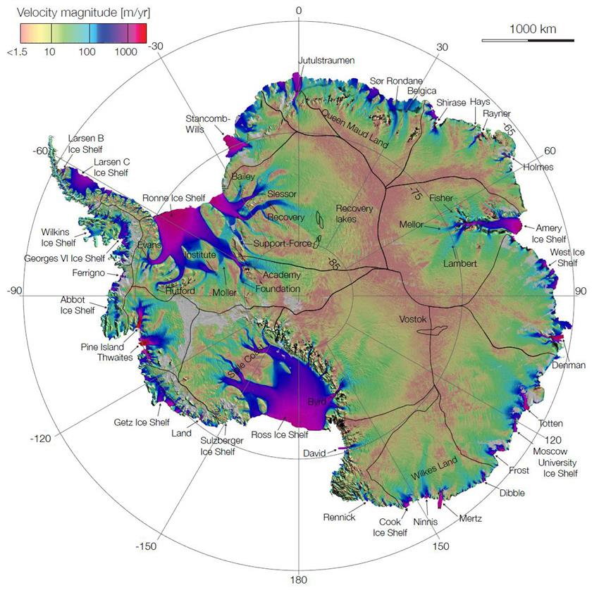
Canadian satellites RADARSAT- 1 and 2 have significantly contributed to completing the first radar-generated map showing the speed and direction of ice flow in Antarctica. Data: NASA/JPL, UCI, ESA, CSA, JAXA. (Credit: Rignot, Mouginot & Scheuchl 2011, Science 333 (6048))
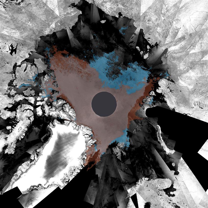
A radar image mosaic, captured by European satellite Envisat ASAR, showing the minimum record amount of sea ice in the Arctic in (red) and (blue). (Credit: ESA)