
Phoenix Mars Mission

Launch:
Status: Mission completed
The Phoenix Mars Lander was the first mission to explore the Arctic region of Mars at ground level. Phoenix was launched from the Kennedy Space Center aboard a Delta II rocket at 5:26 am ET on . It landed near Mars's northern polar cap on in an area known as Vastitas Borealis, where it continued to operate successfully for more than five months (far beyond its planned 90 days).
The Phoenix Mission marked the first time that Canada landed on the surface of Mars. Canada's meteorological station recorded the daily weather at the landing site. It measured Mars' temperature and pressure, and probed clouds, fog and dust in Mars' lower atmosphere. Most significantly, the weather station confirmed that it snows on Mars by detecting snowflakes falling from clouds about 4 kilometres above the spacecraft's landing.
The mission
Phoenix used its 2.35-metre robotic arm to collect samples of the Martian soil for analysis in its on-board laboratory. Among early results, it verified the presence of water ice in the Martian subsurface, which NASA's Mars Odyssey orbiter first detected remotely in . Phoenix's cameras also returned more than 25,000 pictures from sweeping vistas using its stereo camera to particles one millionth of a metre across using the first atomic force microscope ever used outside Earth.
Phoenix's preliminary science accomplishments advance the goal of studying whether the Martian arctic environment has ever been favourable for life. Additional findings include
- documenting a mildly alkaline soil environment unlike any found by earlier Mars missions
- finding small concentrations of salts that could be nutrients for life
- discovering perchlorate salt, which has implications for ice and soil properties
- finding calcium carbonate, a marker of effects of liquid water.
Canada's contribution
Meteorological station
Canada's contribution to Phoenix was a meteorological station (MET) that recorded the daily weather at the landing site. The weather station performed successfully throughout the mission, beginning just hours after landing. The University of Aarhus in Denmark's wind sensor, known as a "telltale," perched at the top of the MET's mast, also measured wind speed and direction and detected the presence of at least one dust devil at the landing site.
The MET had:
- A vertical lidar instrument for probing the atmosphere
- A mast with three temperature sensors at various heights and a wind sensor
- Pressure sensor
Scientific goals
- Track daily weather and seasonal changes
- Use the temperature and pressure measurements to validate atmospheric models
- Analyze structure and depth of the atmosphere close to the surface for information on:
- the location, structure and optical properties of clouds, fog and dust
- how water is cycled seasonally between ice on the ground and vapour in the atmosphere
Like a robotic scientist, Phoenix searched for water in the soil, analyzed the chemical and mineralogical makeup of the Mars terrain, and studied the atmosphere. Canada's MET sat on the spacecraft's table-like deck. Using a laser instrument (lidar) and a suite of temperature, wind and pressure sensors, the MET tracked daily weather patterns and seasonal climate changes on Mars. It was the first time the lidar technology was used on the surface of another planet.
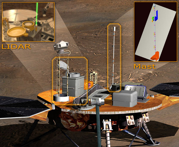
The Phoenix spacecraft and the Canadian components: the lidar and the MET mast thermometers. (Credits: NASA, JPL-Caltech, MSSS)
Lidar instrument

Simulation of the Canadian lidar instrument in operation. (Credits: NASA JPL, University of Arizona)
Working with Toronto-based Optech, MDA Space Systems of Brampton, Ontario, was the prime contractor for the shoebox-sized lidar instrument. The lidar's pencil-thick laser shot rapid pulses of light into the atmosphere, which bounced off passing clouds and dust overhead. The pulses of light were then reflected back to a 10-centimetre optical telescope. The data helped determine the composition, movement, and size of clouds and particles above the lander.
To be able to pierce through much of Mars's thin atmosphere, the laser was fixed in an upward-pointing orientation and worked at two wavelengths so that it could give accurate measurements of cloud height to within 10 metres. The Canadian science team typically ran the laser for 15-minute periods four times daily in order to determine what time of day clouds began to form around the landing site, and to find out if clouds form at various altitudes at certain times of the day. Though it only required the power of a 30-watt light bulb (with a maximum capacity peaking at 40 watts), the lidar could shoot 20 kilometres high into the Martian atmosphere.

The Canadian lidar instrument. (Credit: NASA / JPL / U. Arizona / Lockheed Martin)
By scanning and probing the Martian polar sky in such detail from the ground for the first time, Canadian researchers saw a variety of atmospheric activity in greater detail than ever before. They looked at ice and dust clouds, ground fog, and even saw dust devils across the landing site. Researchers are using this unique data from the red planet's polar region to create a clearer picture of how water cycles between surface ice and vapour in the atmosphere.
Sensors
When Phoenix landed near the north polar ice cap of Mars, the Sun was close to its highest point in the sky, providing almost 24 hours of sunshine. Local temperatures were expected to vary between highs of −33 °C to lows of −100 °C degrees.
The weather station had three temperature sensors. Fixed to the mast at different levels, the top sensor was about 2.3 metres above the ground.
The sensors measured temperature by its effect on the flow of an electrical current through a closed circuit. They were built by MDA Space Missions in Brampton.
About the size of a deck of cards, the pressure sensor took atmospheric pressure readings at the Phoenix landing site throughout the day. It was mounted on the side of an electronics box on the deck of the lander.
The air pressure was about 1% of Earth's. Researchers correlated the pressure data with observations from the other sensors to develop a daily weather forecast for the landing site.
The pressure sensor was provided by the Finnish Meteorological Institute.
Wind monitor
Located near the top of the mast close to a temperature sensor, the wind monitor measured the direction and strength of winds at the landing site. Researchers had to create a small, light device for the lander. Their innovative solution was made of a small tube and a ball. As the wind lifted and moved the ball, onboard stereoscopic cameras captured the movement. The deflection of the ball indicated the wind speed and direction.

Credit: Canadian Space Agency (CSA) / Lockheed Martin
Winds at the Phoenix landing site were typically 3 to 5 m/s (11 to 18 km/h), which increased to an average of about 10 m/s (36 km/h) during the last 50 sols of the mission, when winter weather started to set in. The highest recorded wind speed was 16 m/s (58 km/h).
The wind monitor was provided by Denmark's Aarhus University with support from Canadian science team members.

Illustration of the Phoenix lander. (Credits: NASA JPL, University of Arizona)
Images

On , the Phoenix Mars Lander made a dramatic landing on Mars, with millions of people worldwide sharing the jubilation of the international team gathered at NASA's JPL. Within hours of landing, the spacecraft beamed back images of the rocky polar region of Mars. This panorama stitches together hundreds of images of Phoenix itself and its barren surroundings. (Credit: NASA/JPL-Caltech/University of Arizona/Texas A&M University)

This image of the trenches dug by Phoenix's robotic arm reveals ice as white patches below just a few centimeters of soil. (Credit: NASA/JPL-Caltech/University of Arizona/Texas A&M University)

Phoenix detected quantities of calcium carbonate in the soil. Commonly found in rocks on Earth like limestone and chalk (also a major ingredient of seashells, eggshells and found in broccoli and kale), calcium carbonate led scientists to believe that the environment where Phoenix landed could have once been wet or damp. On Earth, where there is water, there is life. Following the water on Mars is a first step in eventually finding out if Mars was ever – or could still be – an abode for life. (Credit: NASA/JPL-Caltech/University of Arizona/Texas A&M University)

A vertical projection of images taken by Phoenix's on-board cameras, stitched together as if looking downwards towards the lander from above. (Credit: NASA/JPL-Caltech/University of Arizona/Texas A&M University)

This colour mosaic image of the protective cover of the lidar onboard NASA's Phoenix Mars Lander was taken by the Surface Stereo Imager on Martian Day (Sol) 35, . The lidar was part of the Canadian-built weather station, contributed to the mission by the CSA. The lidar proudly bears the same Canada wordmark on its thermal blankets as the iconic Canadarm on the Space Shuttle, Canadarm2 and Dextre, the Canadian robots aboard the International Space Station. (Credit: NASA/JPL-Caltech/University of Arizona/Texas A&M University)

On Martian Day (Sol) 99 of the mission, the Canadian lidar made an unprecedented discovery: it detected snowflakes falling from the clouds about 4 kilometres above the spacecraft's landing site. The colour on this graph shows Martian clouds, with snowfall where the streaks curve towards the right of the graphic, showing that winds are faster at that altitude than at higher altitudes. "Nothing like this view has ever been seen on Mars," said Jim Whiteway of York University, lead scientist for the CSA's Meteorological Station. (Credit: NASA/JPL-Caltech/University of Arizona/CSA)

What could be more Canadian that studying the weather of Mars? Throughout the mission, the CSA's Meteorological Station recorded the temperature and barometric pressure, producing a daily Mars weather report for Earthlings to compare with their home planet. Wind speeds were supplied by Danish collaborators from the University of Aarhus. This weather report is from Martian Day (Sol) 151, the final data sent by the Phoenix lander. Designed to last for 90 days, Phoenix outperformed all expectations by working for over five months. The Phoenix lander ended communications in , about when its solar panels ceased operating in the dark Martian winter. (Credits: NASA/JPL-Caltech/CSA, University of Aarhus)